Tuesday, 30 April 2013
April 10 Viernheim to Le Puy
We took a series of trains via Mannheim, Karlsruhe and Lyon to Le Puy. We had lunch on Lyon Part Dieu Station and noticed the sun for the first time in months. We were not the only folk being surprised the square behind the station was full of folks casting clouts. In Le Puy we followed pilgrims on the Camino into the centre and found the IBIS Styles Hotel. It is a new hotel and part of a chain, so it is lacking in quaintness but we had a pleasant room. We ate in Maitre Kanter next door, a chain restaurant but the food is normally excellent. This restaurant was no exception. We had the menu de terroir. The main course was lentils with roast pork leg. The lentils were chewy, in our opinion undercooked. The lentils in Le Puy are famous all over France. We should have had a quick cultural ramble round Le Puy but it had been an early start and a long day, so we hit the sack.
Saturday, 27 April 2013
The Robert Louis Stevenson Trail
We decided some months ago to walk the R.L. Stevenson Trail in south
central France or at least the core from Monastier to St Jean du Gard.
R.L.Stevenson walked this in 1878 with a donkey to try to forget an
American woman who had rejected his proposal of marriage. We booked
with a tour company who organised the whole trip including hotel booking and baggage transfer. We could
have organised the trip ourselves, but were worried about booking rooms in our schoolboy/schoolgirl French. There is however an excellent website giving
many addresses (www.chemin-stevenson.org) not only about accommodation,
but also baggage transfer and public transport. There is however little
of the latter. Our feeling is, as long as someone in the party has some
French that one could walk the route without assistance. In half the hotels we stopped in nobody attempted to speak English or slow down their French. Early and late in the season you don't need to book.Two guide books would be useful: “Le Chemin de Stevenson”
TopoGuide, ISBN 978-2-7514-0500-6 for its 1:50000 maps, even if you
don’t read French and “The Robert Louis Stevenson Trail” by Alan Castle
from Cicerone (ISBN: 9781852845117) for detailed route and background
descriptions in English. Alan Castle discusses buying the ten 1:25 000
IGN maps needed to cover the route, but we feel that the 1:50 000 maps
in the TopoGuide plus the waymarking are more than adequate for easy
navigation. We walked most of the way without using a map just using the
waymarks. We walked the trail from 11 April which was perhaps a little
early. There were stretches of snow and muddy track that would have
dried up in a few weeks time. On the other hand we had no problems with
high temperatures.

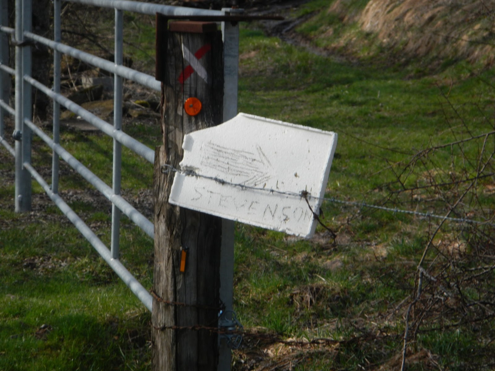
The waymarking is excellent but very varied:
 |
| The official GR 70 signpost |
 |
| You follow red and white stripes. This symbol means turn left. |
 |
| Locals, tired of being asked add their own notices: |
 |
| Sometimes the red and white stripes are painted on rocks: |
 |
| Other notices include an invitation to shelter from the rain: |
 |
| The wilder the country, the more informal the notices: |
 |
| However the tourist offices add standardisation: |
 |
| Turn right! |
 |
| Officialdom again |
 |
| The locals add signs to save time |
 |
| The mud in early April was interesting at times. |
Monday, 8 April 2013
A new app for walkers in the Saarland
A newish app for cyclists and walkers from from the Saarland Tourist
Authority struck us as an excellent idea. The app shows a zoomable 1:25
000 map of every cycle and walking trail in the province with extensive descriptions, profiles, photographs,
sites of interest and restaurants/cafés. In addition the happy or not
so happy wanderer on finding damaged signs or not finding missing signs
can take a photograph and send a message to the tourist authority
describing route problems. If gps is turned on, the location is sent
automatically. When we find a missing sign, we tend curse and promise to
send an eMail when get home, but we often forget. Unfortunately the app
is only available in German the moment, but profiles, maps and photographs don't demand much knowledge of the language. You could of course send an eMail to info@tz-s.de requesting a version in English. This type of app would be of use to folk like Sustrans as well. The app is available free of charge from the Apple iTunes store and the GooglePlay store. Check www.tourismus.saarland.de to find direct links and lots of information on the Saarland. The website is in German, English, Dutch and French, but only the German version offers a link to the app.
Saturday, 6 April 2013
The Weinsteig Part III Deidesheim to Neustadt a d Weinstreaße and disaster strikes.
We took the S-Bahn from Mannheim to Haßloch (Pfalz) and changed to bus 513 to Deidesheim. If you are tempted to take this route be warned: We had three minutes to get from the platform to the bus stop. We did not hang about and as soon as we sat down the bus was away. We left Deidesheim station and took the Bahnhofstraße past the fountain in front of the Tourist Information Office. The fountain is worth five minutes of your time. You can take each others' photographs "wearing" bronze clothing and admire the goat with droppings and the mouse without. We picked up the yellow and red waymarkers showing the feeder route to the Weinsteig easily. We turned left at the end of the Bahnhofstraße to reach the Marktplatz, the square in front of the Deidesheimer Hof, a restaurant visited by the great and the good when Helmut Kohl was Federal Chancellor. However the restaurant still serves basic Pfälzer food like live dumplings, Saumagen (stuffed pigs stomach) and sauerkraut at reasonable prices. You can also eat a four course gourmet meal for €66 with a different wine for each course. We put ourselves out of temptation and took the Heumarktstraße on the far side of the town hall following the red and yellow waymakers. We passed the swimming baths and climbed through the vineyards towards the Pfalzblick, a restaurant. Along the way the markers changed colour to the familiar red and white squares. We walked along the edge of the forest overlooking the vineyards before dropping down into Gimmeldingen and then climbing back in to the forest into the Gimmeldingener Valley with its three guest houses. By Forsthaus Benjental, the last one we started the four kilometre up hill hike (300m) to the summit of Weinbiet hill. The path is not good and care was needed. The Pfälzer Wald Verein (Palatinate Forest Club) restaurant was shut. It was Friday and Ruhetag. Once away from the summit the wide smooth path dropped steadily and somewhere along here I tripped over my feet. I fell heavily, cut my knee and bruised my left side. I will take walking poles in future. Judith played the nurse and applied sticking plasters. I hobbled along dribbling blood on my trousers to the stone deer, a carving by whom we don't know.

There is a wet red spot on my right leg.
We climbed down the technically difficult section by Wolfsburg (the exposure is quite fierce) and took another waymarked feeder into Neustadt. We visited an Apotheke - a chemist's shop to buy plasters, a bakers for a cup of coffee and the station to catch the S-Bahn back to Mannheim.
The route is well waymarked and we did not use our guide or our map.
Monday, 1 April 2013
The Weinsteig Part II Bad Dürkheim to Deidesheim
The weather forecast for this morning was not very clear. As the promised fine day yesterday gave us a snow shower and a wind from the Arctic regions, we did not expect any good weather this morning. When I looked out at about 07:30 I saw blue skies and sunshine. I woke Judith up. We breakfasted and drove to the Rhein Neckar Zentrum's car park to take the OEG to Mannheim HBf where we took a Rhein Haardt Bahn train to Bad Dürkheim. The RHB stops in front of Bad Dürkheim station. We walked down to the main road, turned left and crossed the road on the corner to walk up the Mannheimer Straße. We had had trouble finding a café when we here last week, but had we walked another 100m along the Mannheimer Straße we would have found half a dozen. We turned left at the Stadtplatz (Town Square) and followed the Weinstraße (Süd). By this time we had picked up the red and yellow markers Weinsteig feeder markers and swung right by the pizza restaurant to climb out of town. The signposting was superb all day. At the end of the tarmac we followed a basalt cobbled road and then turned right towards the Flaggenturm, the tower on your right. We climbed up to this and it wasn't the last climb of the day, The view from the tower was good but hazy. We climbed through the forest before we dropped steeply and then climbed up over another ridge where we had views of Wachenheim. Yet another steep drop to a campsite before we climbed up to the Wachtenburg ruined castle - restaurant and then climbed on for some time before we dropped off the edge of the world to reach Deidesheim. The usual deal once we got there and we lost the way markers, so wandered round the village in circles until we found the railway station. (Just turn left by the Deidesheimer Hof and turn right down the Bahnhofstraße.) We just missed a train and so had to wait half an hour for the next. We could have taken a bus to Ludwigshafen, I suppose. Train back to Bad Dürkheim and RHB to Mannheim, OEG to Viernheim.
Subscribe to:
Comments (Atom)