Monday 18 November 2013

Honister Slate Mine to Keswick on Remembrance Day

On Remembrance Sunday 2013 we were stopping with friends in Keswick. They had volunteered to man the car park at the Honister Slate Mine to collect for the Poppy Appeal. There is a tradition in the Lake District that there is a Remembrance Day Service on Great Gable. The car park at the Honister Slate Mine is one of the nearest car parks to the peak.  Our friends had to be there by 07:00, so we left their home at 06:30 and climbed into their frozen car.
It was light by the time we reached the slate mine and we set off round the back of  the Youth Hostel following the miners' trail downhill. We'd decided not to go up to Great Gable because we would have needed to take the same way back against a flow of visitors, as our friends were due to stop chinking tins at 10:00. Our aim was to walk down to Grange in Borrowdale. 
The track was good, though slippery in parts and easy to follow. This was good as British waymarking is very patchy compared to the Teutonic systems we are used to. It was a very clear and fresh morning. The high peaks around had a dusting of snow from the storms of the day before. As the sun lit up the frost covered floor of Borrowdale it resembled nothing less than a water colour painting. We negotiated the back of Castle Crag with care as the way was steep with many loose stones. We had a cup of tea and a piece of cake in the Grange Cafe. Our friends arrived and suggested that we walk back to Keswick. We did not hesitate and took the Panorama Way overlooking Derwent Water before dropping into Portinscale and the outskirts of Keswick. Length 17km - about 10 miles.
Even if you have not got friends prepared to offer their car as a taxi service you can take a bus from Keswick up the pass in summer that will bring you to the slate mine. The Slate Mine has a cafe and sells excellent bacon butties amongst other items.

Leaving the slate mine car park.

Looking down into Borrowdale


Castle Crag to the right. Derwent Water and  Skiddaw to the front.

Derwent Water

Sunday 17 November 2013

Aldi walking gear

Some time ago I was amused to see a note on the BikeRadar blog about ALDI's cycling gear. Our outdoor cupboards show lots of Crane labels. We have bought both cycling and walking gear from ALDI-Sued over the last few years. The gear is excellent. I have recently acquired a couple of Crane polyester walking shirts and in spite of their cost, i.e. €9.99 they are very comfortable and warm. OK they don't have the zipped pockets and hanging tabs that the Rohan shirts feature, but they are a factor of four cheaper. ALDI-Sued socks wear well.
Obviously if your life depends on your gear then it's a wise idea to buy a well known brand, but if like us you are just going hill walking at low levels and you are not worried about status then ALDI's walking clothing fits the bill. It is mostly not made in Europe but there again most of the big names are embroidered on clothing made in the far east. If one of them starts to make stuff in Europe again then we would change our suppliers. I suspect though in this case, it is not a wise policy to hold my breathe.

Wednesday 2 October 2013

Walking in Vogtland

Near our hotel
Last week we spent a week walking in Vogtland, east of Hof and Bayreuth (Bavaria) and stopped in Bad Elster, (Saxony) one of a number of spa towns in the area.  The area is criss-crossed by well waymarked trails. The town of Bad Elster is good base. There are regular concerts, a magnificent baths and some good cafés. There is a basic public transport system: Buses and a railway line south into the Czech Republic and north to the German mainline railway system. The one snag is that the railway station is 3km out of town. None of the normally well organised Germans seems to have thought of a shuttle bus to link the station and the town, so it was Shanks’ Pony which made for a long day.
We walked between 15 and 20km most days through woods and across open fields with good views of the Vogtland hills. For me the two high spots were:
Františkovy Lázně 

  • A good day walking from Cheb to Františkovy Lázně (Franzenbad) passing a volcano investigated by Goethe. The site is marked by a plaque in German. Františkovy Lázně is elegant in a French Empire style and has numerous springs where one can take the waters. They taste healthy, uugh! The Czech - German border is open thanks to the Schengen Agreement.
  • The day we walked across the heathlands to Markneukirchen, a centre of quality musical instrument manufacturing, (The cheap stuff is made in Asia.) The museum there has a fantastic display of musical instruments. It also has an excellent value for money café on the main drag where we made up our missing calories after the exertions of the walk. Prices here are less than farther west, but are still higher than in the Czech Republic which are ridiculously cheap: Three of us ate a three course lunch with a genuine Budweiser beer in a very comfortable restaurant near Cheb for €20 total.

Sunday 25 August 2013

Walking in the southern Black Forest Day 6 St Blasien to Todtmoos

The view from our hotel window

Open fields and forests

The "monster" at work

The Fairy Glen
Another wonderfully sunny morning, though some of the "spectacle viewers" of the night before, a little short of sleep, had a somewhat jaundiced view of the world. We walked through the town and could stock up on a sandwich for lunch, before diving under the bypass to climb steeply over Lehenkopf with the Bismarck Tower. There were already excellent views of the cathedral and the cloister buildings, so we did not climb the tower, but made our excuses and left. We walked down into the pub at Klosterweiher where we enjoyed a Radler before climbing 2km to the Kreuzfelsenhutte shelter hut to eat our sandwiches. We could have had lunch in the pub, but a beer  and a large lunch slows us up even more in the afternoon. We continued on through forests and around fields containing a bull, a number of cows and calves to climb to the Peace Cross above Ibach where we were promised a view of the Alps. It is more than likely true on a cold clear day, but with the haze it was difficult to recognise anything, though J and C swore they could see snowy peaks through binoculars. We crossed open country and climbed into forest where we were treated to a display of modern forestry techniques. A monstrous machine was reducing large trees to matchsticks. After another a stretch of forest we crossed the main road to walk steeply into the Hohwehraschlucht  (Upper Wehra Gorge). The last part of the route before Todtmoos was an interesting path through a “fairy glen”, a babbling brook, pools and light and shad from a variety of trees.

Saturday 24 August 2013

Walking in the southern Black Forest Day 5 Fischbach to St Blasien

Breakfast at the hotel was reasonable but a bus party had played the flight of locusts just before us and pickings were rather thin. Neither baker nor butcher were within view as we left the Gasthof Hirschen, so we could not buy sandwiches for lunch. Our first priority was to buy victuals. The wide farm track by the hotel led to a gentle climb through the forest over Bildstein peak (1130m) where we had good views of Lake Schluchsee. We dropped down a winding narrow path down to Aha Bahnhof (Railway station) on the lakeside. The kiosk there was not yet open, so we went on to Aha and bought dry Brötchen (rolls) in the kiosk at the start of the hamlet. We still had a tin of sardines.  As we found out there was only one other chance before St Blasien to obtain refreshments. We walked round the lake on a wide unsealed road with many other walkers and cyclists, who were only going as far as the café at Unterkrummen (4km). After the café we climbed over Krummer Kreuz on forest roads. Although it remained dry the weather was overcast and much cooler. There were a number of traditional Black Forest farmhouses with their bonnet-like roofs stretching along the Halbmoosbächle Valley. In Althütte we caught glimpses of what we decided was Lake Constance. A steep drop past the Windberg Waterfall brought us into St Blasien on a pretty but difficult path, in another gorge much strewn with large trees blown down in a great storm. We arrived at the hotel by 16:00 and spent some time out in the town victualling, so did not have our usual late afternoon siesta. St Blasien was in the hands of amateur thespians, some of whom we observed over an excellent coffee and cake. The town organises an annual son et lumière event and that night was the first night. Our hotel, Dom Hotel was in front of the cathedral and at the back of the viewing stands, but within hearing distance. The event started at 21:15, finished shortly before midnight and the audience must have been glad of woolly jumpers and/or quilts. Temperatures were low below 10°C. I was worried I wouldn't be able to sleep, I dozed off while watching the beginning and slept well until early the next morning.
Climbing out of Fischbach

First view of Lake Schluchsee

Black Forest farmhouse

Descending to St Blasien 

Friday 23 August 2013

Walking in the southern Black Forest Day 4 Schattenmuhle to Fischbach

The hotel did not offer a breakfast buffet as was usual at the other hotels, but we had a good choice of ham, Wurst, cheese, jam and honey to go with rolls, bread, coffee and tea. There were no shops for miles so we enquired whether we could purchase three dry rolls to make our sardine sandwich lunch and were given three. We left the hotel and climbed steeply then followed a high level path via Räuberschlössle - the Robbers’ Little Castle which is the remains of a castle on a peak later taken over by gangs of low life types. It would be an ideal place to set a Swallows and Amazons story. We walked on and passed the Stallegg hydro power station, one of Germany’s first hydropower stations. It did not appear to be functioning when we were there. The dam was empty. Perhaps the station was being maintained. During the next kilometers into Lenzkirch crisscrossing a former railway line now used as a cycleway it seemed that we no sooner reached the summit than we dropped again in order to climb back up again. I suspect it is better to follow the cycle path into Lenzkirch and would have done this but my companions had moral fibre. We had to walk the whole route with no compromises. We had a coffee break in the Kurhaus before we began the long climb to Fischbach over Fischerbacher Höhe (1101m). Initially it was very pleasant in the shady woods up to the Geopark with its mini library and chunks of local rocks, but when we came out in the open fields by the Cyriak Chapel walking there was some sweating and puffing. The road seemed to go on forever. We dropped into Fischbach and arrived at the Gasthof Hirschen after 22.5km with 600m climbing. We very were pleased to be offered a Radler as a welcome drink.
The library at the Geopark site

Discussing erratics

Nothing better than a shandy after a long day

Thursday 22 August 2013

Walking in the southern Black Forest Day 3 Blumberg to Schattenmuhle

Schleifenbach
Wutachmuhle
In the gorge


We had trouble with the Hotel Hirschen’s WiFi system. This may be related to the devices we were using: mobile phone, netbook or e-book reader. Whether this is a language problem, because our devices use English or whether the signal was not strong enough, we don’t know. In our experience it is not easy to use WiFi away from home as we found in several hotels underway. This is a plus point in our opinion. However mobile phone coverage in the gorge is very patchy as well, perhaps the perfect excuse when the boss complains that you could not be reached. More importantly, we enjoyed an excellent buffet breakfast, bought three filled rolls for lunch at €4 for the lot and walked back onto the trail. All of our hotels were within a few hundred metres of the trail. We followed Hauptstrasse west and then walked straight on to go down a steep path on the left. After some zigzags with serious exposure we reached a ladder with about 20 steps by the Schleifenbach waterfall – an impressive dark cove of rock. A climb followed along a forest and field path to the pretty village of Achdorf. We walked through the village  to reach the fields; followed a minor road, then crossed the Wutach to go through woods and clearings to reach the Wutachmuhle, an old mill. We wandered through the timber yard to follow the path in to the narrow, twisty Wutachschlucht. The path is technically difficult from time to time over tree roots, climbs very steeply over loose greasy stones, drops to rock shelves by the river and returns high over the river with a cliff face on one side and a vertical drop on the other. It is a spectacular experience, certainly no after lunch Sunday stroll. The route is popular and was busy with walkers coming towards us which slowed us down on the narrower sections. There was a lot of up and down before the day ended in the remote Gasthaus Schattenmühle, cut off from the outside world. The kitchen closed at 8 pm. Carbo-loading was the order of the day, so we ate excellent Rösti , topped with pork steaks or Black Forest Ham, followed by Kaiserschmarren. Our room was simple, but after 20km  and 380m climbing in about seven hours it was all we needed.


Wednesday 21 August 2013

Walking in the southern Black Forest Day 1 and 2 Stühlingen to Blumberg

Day 1
We drove down to Stühlingen and left the car there. We were lucky that our first hotel: Hotel Rebstock in Stühlingen was the epitome of the historic Black Forest inn, hotel staff in local costume. We ate very well on Saturday night. The food and drink complimented the amazing table decor.  
Day 2
We left early on Sunday morning after an excellent breakfast as the sky cleared and the sun came out. We walked along the German-Swiss border gently burping Black Forest Ham until we were diverted across the Wutach into Switzerland. There was logging on the German side. There were no border controls as Switzerland although not a member of the EU has signed the Schengen Agreement. The temporary signage was excellent. We crossed the line of the Sauschwänzle Bahn, the pig’s tail railway, a museum railway that climbs via a series of loop tunnels and viaducts up to Blumberg. As we looked at the halt buildings by the road side we heard the familiar noise of a steam train climbing the gradient towards us. We waited and watched a Rumanian steam locomotive probably as old as we are pull the morning train from Weizen to Blumberg. Gradually we climbed along the precipitous side of the Wutach Valley along a narrow, rutted and stony path. In the growing warmth of the morning we were grateful for the woodland. We were later amused to read a notice put up by the Black Forest Club explaining that this section was difficult and dangerous. We should take care and notice that the route is divided into sections to help the Bergwacht (Mountain Rescue) find us more quickly if we put a foot wrong. A little late we thought. The route lead us away from the valley over Buchberg Hill through open fields. It was very hot and we were glad to reach the forest on its upper slopes. We had a short break at the viewpoint overlooking the village of Achdorf which we would visit the next day and then wandered into Blumberg and the Hotel Hirschen. This was a much more modern hotel, but equally comfortable and with good food and excellent local beer. 
22km, 540m, Time taken: 8h


Tuesday 20 August 2013

Walking in the southern Black Forest Introduction

Some months ago a former colleague suggested we spent a week walking this summer. We had been cycling together before, but I think she was tired of waiting for us at the top of hills and maybe she hoped we would be quicker on Shanks’ Pony. (We weren’t or at least I wasn’t) 

We thought we’d stay in Germany: There is a lot of excellent walking in Germany and we speak the language. After some thought we settled on the Schluchtensteig in the southern Black Forest. (For those who are not familiar with the language of Goethe: Schlucht is a canyon or a gorge. Steig is a steep track, i.e. Schluchtensteig is a track through a gorge. The route has been laid out by the Southern Black Forest Nature Park, and the Black Forest Club. It is 119km long and runs from tiny Stühlingen on the Swiss border to Wehr on the Upper Rhine. The route falls well into 6 days, i.e. about 20km a day. Fitter and faster walkers can complete it in five days, but the views are worth savouring. Most hotels on the route offer baggage transfer to the next hotel, but not a sag wagon that follows the walker, though some hotel landlords might take you as well as your bag if necessary. After looking at various possibilities we booked a trip with Kleins Wanderreisen GmbH. The company’s website and approach seemed to be a good one and we were not disappointed. We did “cheat” as a Canadian lady we met in Wehr suggested in that we did not carry our gear, but at 70 plus we are both beginning to enjoy some of the perks age brings. Our luggage went on before and we followed carrying day rucksacks.  

Tuesday 9 July 2013

Post from the Ramblers about walking and cycling holidays in the Rhine Gorge

I was amused yesterday morning to get a newsletter from Ramblers' Holidays - the commercial end of the British Ramblers' Association. We have had a number of holidays with the Ramblers. All of them were good. Some were better than others. The newsletter was enclosed with a brochure on cruising and walking which was binned very rapidly. I have no desire to have to pack a penguin suit to eat dinner.
However the newsletter had an article by Martin Hesp, the Senior Features Editor of the Western Morning News about a holiday in Rüdesheim where he praises walking and cycling in the Rhine Gorge. We have been pushing the advantages of holidays in Germany for well over twenty five years: Prices are cheaper than in France. More people speak English. The food comes in huge portions, but is very similar to British tastes. The wine is reasonably priced and much underrated in Britain. The beer is wonderful. There are excellent networks of cycling and walking routes, backed up by good public transport.
Over the next few months we will try to describe some of the long distance walking routes to help Ramblers work out some more good holidays in Germany. Watch this space.


Sunday 2 June 2013

Emergencies while walking

We have just returned from a day walk with with our local walking club to Enzklösterle in the Black Forest. The club walks regularly attract 70 or 80  participants. We split in two groups, one to do a shorter walk and one for a somewhat longer walk. We chose to do the longer walk at 12km as did about 30 others. It was a great day. The weather was perfect, sunny but cool. We wandered through a chunk of the Black Forest that has been left in its pristine condition. At the end we climbed steeply over a ridge. As the walk progressed our leader started to show problems. He's got heart trouble and has recently suffered from 'flu. He felt very weak climbing the last hill and a first aider went back to check him out. The rest of us waited at the summit wondering what to do. After some time the leader was assisted up the hill and could walk gently to the bus, but the whole episode delayed the rest of us for the better part of an hour. Fortunately could follow the excellent Black Forest Club waymarking, but if this was not there, then we would have had problems, if the leader had not been able to show us the route. We could walk down to our bus and arrived late at the restaurant for lunch. It struck us that the club would be well advised to

  • appoint a back up leader for each of the walks so that he or she can take over in case of emergency.
  • to distribute mobile phone numbers so that one can communicate with members of one's own party and with the other party to warn the others, the restaurant and/or the emergency services. 
We will suggest this to the committee in the coming days.


Saturday 18 May 2013

Rohan

At the end of last year I bought a Rohan "Wayfarer" shirt in their Long Preston shop. Rohan is a British supplier of outdoor clothing. The shirt was the end of a line and reduced in price. I buy most of my walking gear this way.  I wore the shirt on our walking holidays in Avignon and also on our Stevenson trip. Without wishing to sound like a commercial, it was comfortable to wear, looked reasonable and easy to wash. However after our return from St Jean du Gard, Judith noticed that there was a sewing fault on the shoulder yoke. I sent the shirt to Rohan with just a short note and without a bill. A few days  later I was contacted by the company and  talked to a member of staff at HQ who told me that the shirt was faulty and as it couldn't be repaired, the company would send me a new one. Yesterday a DHL packet arrived with a new shirt. Well done, Rohan.

Saturday 11 May 2013

St Germain de Calberte to St Jean du Gard (22 km 350m)

We'd been asked the day before when we wanted to depart from the village and replied that we would be happy if we could eat breakfast at 08:00 and be on our way by 09:00. The farmer was surprised because a lot of walkers like to leave early in summer to avoid the worst of the heat. This was not a problem for us. I think if I'd been planning the trip I would have made an overnight stop in the next village on the route: The oddly named St Étienne Vallèe Française as the day before had been too short and the last day was a bit long. It would have meant however that we would have missed out on the visit to the Ferme de Lancizolle.


Our sleeping quarters at the Ferme.

On our way to breakfast. (The dog moved as we approached.)
We were dropped off in the village, bought some bread and sent off on our last day along a path running parallel to the D984.

The view back towards St Germain
Later on we joined the road for a few km, but traffic was light on a Sunday morning. We ate our sardine sandwiches in St Étienne Vallèe Française and then climbed over our last ridge (600 m). The way up was not difficult, but the drop on the other side was interesting, steep and rocky.
We dropped into the Gardon Valley through the hamlet of Pied de Côte.
We turned left at the D907 and followed it. It was not that pleasant. The traffic seemed to be moving very quickly. What it is like in summer I am hesitant to think. Fortunately after two km or so we could nip off along a footpath away from the road marked by red and white stripes. We crossed the Gardon and walked down the right bank into St Jean.
The railway station is one end of an historic steam line, but unfortunately does not offer services connecting with the French mainline services. It is very quaint but a decent rail service or even a bus service to Alès would be preferable. (There is a good bus service to Alès except in the school holidays when there is one bus a day!)
St Jean railway station.
We stopped in the comfortable Hotel Les Bellugues converted from a silk spinning mill and ate like Robert Louis in the L'Oronge. Next day we took a train home and since we had failed to obtain a Prem ticket it cost more than twice the outward fare.


Friday 10 May 2013

April 20 Cassagnas to St Germain de Calberte (15 km 200 m)

The weather was cold and windy. We had the odd snow flurry later in the day. Today was billed as a short day. We set off and walked up into the forest.
This was a mistake. We should have explored the village of Cassagnas first. 
There is a holiday village with café at Serre de la Can on the way through the forest, but we were too early by a few weeks. The café was shut so we continued in to St German de Calberte and arrived too early at 14:00. Pickup time was 17:00. Our instructions were insistent that we did not ring the farm. It was a working farm. We had a quick coffee in the one bar in the village and found a brochure describing a walk around a series of posters in the village.
We zipped up our jackets and followed the trail, past the Protestant church, the Catholic Church, an exceedingly bare statue and a social centre that during WWII was home to 42 Jews. The Protestant vicar helped these people stay hidden. The Postmaster or -mistress binned any letters of denunciation. The Gendarmes kept their eyes shut when necessary and the school teacher registered any kids under false names.  These people survived even when the village was searched by the Vichy Militia.

Robert Louis Stevenson also came here. I don't know whether he found a sheltered spot by the Polyvalent Hall but we did and ate the remains of our packed lunch. We popped into the village supermarket and returned to the café for a second cup of coffee. At 17:00 the farmer arrived from the Ferme de Lancizolle in his well used Land Rover and as we dropped off the edge of the world into the valley below, he asked what time we'd arrived. We told him and he asked why we hadn't rung him? I suspect one can be too polite at times.
The evening was interesting. We were the only two English speakers speaking Mancunian French with ten native French speakers. We didn't say much, but it was a long jolly evening with a lot of laughter and excellent food: Nettle soup, rabbit paté, roast rabbit with sautéed potatoes and a powerful green bean with garlic sauce, cheese and chestnut and chocolate mousse. Chestnuts still feature heavily in the more ethnic menus.


Thursday 9 May 2013

April 19 Florac to Cassagnas (16 km 200 m)

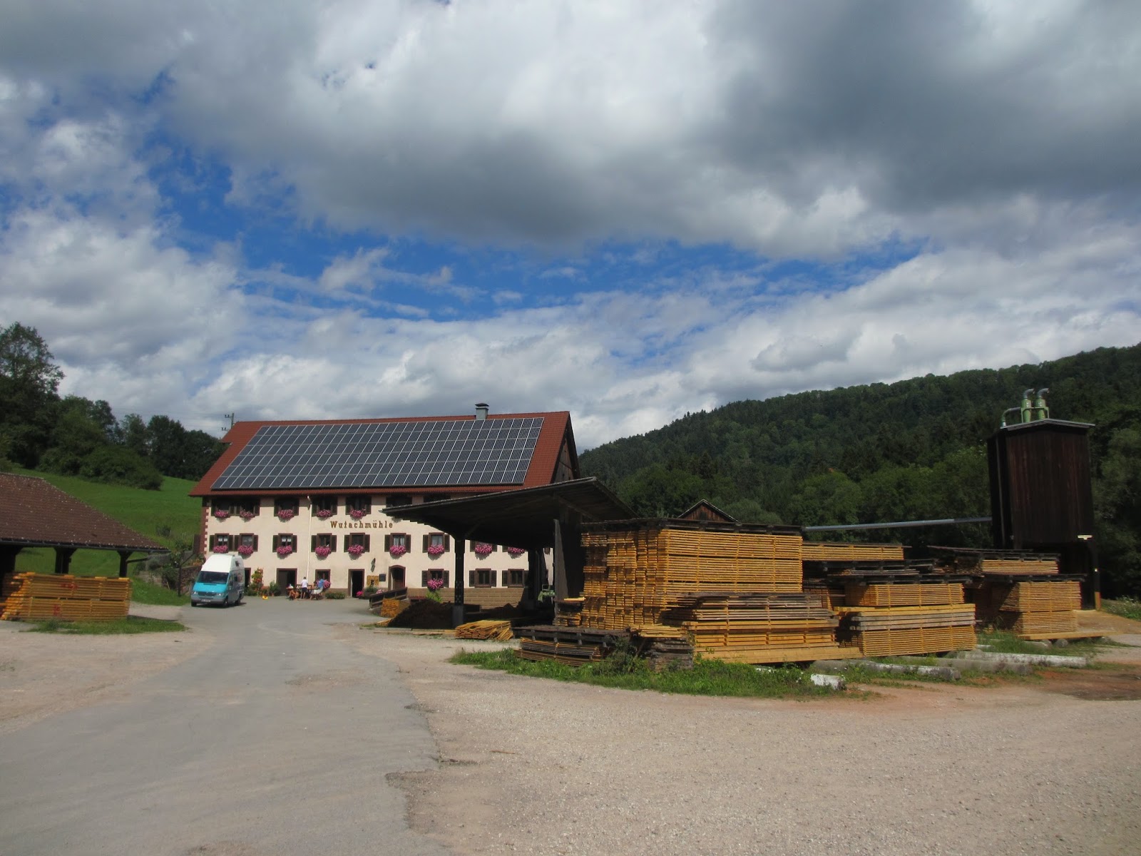
We had a wet and grey start to the day. It stayed grey all day but the rain slackened off later. We needed some victuals, so spent time wandering around the centre of Florac. This a slightly shabby but quaint town centre, somehow very French. There are a number of souvenir shops, travel agents and the like. We were in tourist country again. We found a grocery and stocked up before taking the red and white route along a moderately busy road.


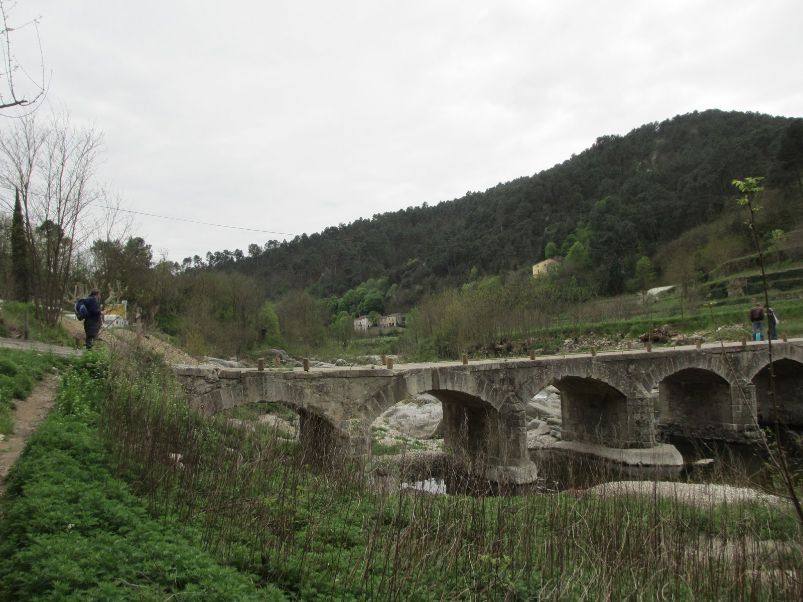
We walked in indian file on the left hand side of the road for a km south of the town and then turned left across an historic bridge, then left again to follow a minor road/track running parallel to the N106 road and the former route of the metre gauge railway line to Florac across the Mimente River.
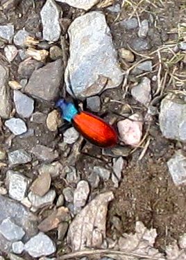
In spite of the flowers

and being watched by two deer up in the woods above us, we managed to avoid stepping on an iridescent beetle on the path.
We dropped down to St Julien d'Arpoan, crossed the river and climbed to the track of the former railway line. One item we missed walking the Stevenson Route was somewhere to eat a picnic, especially on wet days. It was raining quite hard at this point, so we walked round the back of barn used by the local cheese making or egg cooperative and ate our lunch sitting in the entrance porch. Much to our embarrassment a delivery lorry turned up  and we had to pack up quickly. We walked along the old railway line to Espace Steveson. There is a serious difference between continental Europe and Great Britain, at least the Great Britain of recent years. This can be summed up in the words "Health and Safety". Neil is walking across a railway bridge in the photograph below with a tree high drop to the river below. There are neither railings nor warning notices. The French authorities assume that cyclists and walkers have enough sense of self preservation not to walk or cycle too near the edge.

We walked on to the Espace Stevenson a pension, restaurant and campsite based on the former railway station in Cassagnas.


We enjoyed a jolly meal with four other walkers: Mushroom tart, salad, home made sausage with herbs and swiss chard, potatoes gratin, chestnut brownie and fromage blanc with chestnut jam and a demi of red wine between the two of us. A good night!

Wednesday 8 May 2013

April 18 Le Pont de Montvert to Florac (About 20 km, about 350 m)

We knew that today would be hard work. The suggested official GR70 route is 28 km long and involves climbing 545m. There is a minor short cut by taking the GR68 path which saves 4 km. We were worried about this. The landlord of the Auberge des Cévennes told us of a short cut.We took it. He reckoned we would save 10 km on the day. We doubt this but we saved at least 5 km and about 200 m climbing. The landlord used a highlighter on our TopoGuide to sketch out the new route. The official route climbs just over 200 m from the village up to a plateau at about 1100m and climbs further south to a ridge at about 1300 m and then turns west along the ridge to climb to 1400 m before dropping to ca 1100 m by the Col du Sapel.  His route branched off SW on the plateau at point shown in the Le Chemin de Stevenson Topo Guide at point 37, followed a minor road to reach the D20. At this point we were recommended not to follow the D20 but to follow a forest path right and loop round to the D20 later.
We were pleased to have this ace up our sleeve, as we could not leave Le Pont before we picked up the makings of lunch. The baker's shop was shut on Thursdays and the other shops did not open until 09:00. We were somewhat late leaving. We panted up the steep slope to the plateau.
The view back into Le Pont.
We crossed the plateau and followed the landlord's instructions.

Following the forest path and four other walkers in the know.
We then followed the D20 for several kilometres. The road was quiet. In the hour or so we were walking along it we saw 4 or 5 vehicles. We realised why when we arrived at the Col du Sapel. The road downhill was marked as difficult and dangerous.
The view to the the north with the snowfields on Mount Lozère just visible.
The Col du Sapel
We followed GR 70 to junction with GR 68 along a forest road. We had good views down to the road taken by RLS.

 The flowers were superb:


At the junction we climbed to follow GR68, but not that far. GR70 seemed to be less of a good bet, because we would need to walk on a busy main road and it was further. We went steeply down into Florac.

On our way into the village we passed another Carrefour supermarket. Our hotel: Hôtel des Gorges du Tarn, yet another Logis de France was at the other end of Florac. The room was excellent with TV and WLAN, so we could download the "Guardian". The food in the restaurant was good but the portions were somewhat  small:  Salad with goat's cheese, zander (pike perch) with polenta and veg, cheese and fruit salad or yoghurt. Walkers need serious amounts of stodge. We drank a glass of reasonable but expensive  Chardonnay.

Tuesday 7 May 2013

April 17 Le Bleymard to Le Pont de Montvert (18 km 630 m)


Sunny morning. We crossed road into the Carrefour supermarket and bought goodies before climbing steeply out of village through woods to reach a plateau and then the ski centre. The peak loomed before us, but we put one foot in front of the other and carried on.


We and two French guys had a little trouble finding our way out of the centre. (Go to the right of road and head towards pyramid where you pick up the red and white stripes.) It was a long easy climb to the summit on muddy tracks. We had good views from summit though there was haze in the distance.
Neil playing Beau Geste.
We started down the south slope which was covered in deep snow, although the north slope was almost snow free(?). We found the route more by luck and following other people's tracks and went steeply downhill in a stream.


We followed the stripes into the hamlet of Finiel and had a Cornish afternoon with great piles of granite boulders scattered like cannon balls in the fields. The hills in the background are the Cevennes.

The path was interesting and steep. We'd noticed on several days that we could see our destinations, long before we got there, but the steep descents into the villages were such that it always took us longer to get there than we expected.
Le Pont de Montvert has a Mediterranean feel about it and it was surprising to see people in shorts and T shirts sitting on the café terrace. We met Celine, the young woman from Cheylard. We found our hotel over the bridge. We stopped in the Auberge des Cévennes. We had an enjoyable meal of soup, pork fricassee, cheese and creme caramel that evening.
The Auberge des Cévennes is the building with the balcony

The bridge at Le Pont de Montvert where dreadful things happened in the name of religion.