Monday 28 March 2016

Walking the Weinsteig, Rheinland Pfalz, Germany Stage 2: Neuleiningen to Bad Dürkheim

Stage 2: Neuleiningen to Bad Dürkheim, February 12, Distance 17km; Height climbed about 400m; Walking time 4 3/4 hours
Weather: Dry, mist hugging the valley floor, sunny later, temperature 4-9°C, good visibility.
In early February we returned to Neuleiningen to pick up the second stage of the Weinsteig. This is very different with little open country, but the signposting is excellent. This is very important on routes through woodland. Starting in the valley below the town we climbed through woods of pine, beech, or oak with the occasional larch. To the north we glanced back at Neuleiningen, perched on its crag above the incised valley of the  River Eckbach, then on to Battenberg with yet another castle ruin, battered initially by the French in 1689, still used by local nobility into the 18th century. However, what we found much more interesting were its ochre-coloured weathered rocks exposed on the roadside below the ruins. They are signposted off the trail to the right. These curious formations are known as Blitzröhren, thought to be caused by lightning strikes. Modern explanations are that they are due to concentrations of iron minerals in New Red Sandstone which resist weathering.
Back to the route, up through the village and away from inviting offers of lunch it was time to start the long but relatively easy climb using forest paths, liberally studded with white quartz pebbles. Away from the front edge of the Pfälzerwald, up and up leaving the wine villages such as Weisenheim am Berg below on the fertile fault line margins. We met no one today on this part of the  trail and it was still too cool for many birds to be about. After some steady walking we reached  the Jägerkreuz, a memorial to a hunter who died  mysteriously in 1702. Accident or murder? It seemed a good idea to press on and gradually we reached parts of the trail better known to us from earlier walks. Off to our left lay the Ungeheuersee (Monster Lake), in reality a delightful pool, but the Germans like to frighten. No point in a detour today since the typical Hütte which serves food and drinks on summer weekends would still be shuttered and locked for the winter.
We continued gently rising and falling sometimes with glimpses of small settlements like Altleiningen revealed as hill and valley sides open out. At last a few walkers appeared as we approached the first road to cross the Pfalzerwald, south from Neuleiningen, at Lindemannsruhe. The old Forester's House is now  a restaurant, with a cozy atmosphere and tasty local food, as we knew from previous visits. However February days are still too short, so we pressed on up a rough track to the day’s highest point (487m) at the Bismarckturm (Bismarck Tower).  Still surrounded by tall beeches and Scots pines the route returns over rounded hills, past the Teufelsstein (Devil’s Stone) a large weathered boulder and then past moss covered Celtic stoneworks to the edge of the plateau. Finally the trees opened out so we could glimpse the Rhine Plain. At a shelter hut above Kriemhildenstuhl we paused to read the information above the sheer drop into a quarry (fenced off, fortunately). The quarry was used by Roman stonemasons, who left some graffiti, readable from the grassy quarry floor below the steep pathway. Our knees were protesting as we crunched through leaf debris from the chestnut trees down more zigzags into the outskirtsof Bad Dürkheim, a delightful little town, and finally back into the vineyards. Bad Dürkheim is a place to savour and enjoy, where we often take visitors and meet friends, but after a long walk it was time to head home, through the dusk. I'll enlarge on its delights in a later post.
(Otto von Bismarck, 1814-1898 was, at first, a minor figure from Prussia, who through fortuitous circumstances and sheer force of personality, succeeded in uniting the  numerous dukedoms, principalities and fiefdoms into the Pre-WWI country of Germany. He became the first Chancellor. He was revered by many during his lifetime and there was a cult of building towers and lookout points. Though many of these seem aggressively Teutonic in style, they do serve as landmarks especially in forested regions and offer good views.)
Looking at Neuleiningen from the Weinsteig
The Blitzröhren


The hunter's cross memorial

Storm damage hazards are frequent
Teufelsstein has tempting footholds for energetic walkers
Bad Dürkheim's Schloßpark in summer

Monday 7 March 2016

Walking the Weinsteig, Rheinland Pfalz, Germany Stage 1 Bockenheim to Neuleinigen

For several years now we have played with the idea of walking the Palatinate Weinsteig along the edge of the hills above the Rhine Valley on the left bank.  The way marked Weinsteig walking route is 171 kilometre long - just over a hundred miles. It has recently been extended and the route now starts in Bockenheim an der Weinstraße, runs through Hambach, Neuleinigen and Wachenheim with their castles; two spa towns: Bad Dürkheim with its giant wine barrel and Bad Bergzabern; Deidesheim where former federal Chancellor Kohl has enjoyed many a Saumagen with Sauerkraut; Neustadt an der Weinstraße to Schweigen-Rechtenbach with its Weintor and across to Wissembourg in northern Alsace.
We live just north of Mannheim and the whole Weinsteig region lies within our local transport area. We have pensioners' tickets, that we pay for, but give us free transport everywhere in the area. This enable us to reach the start of the walks and return home in the evenings. Bus, tram and local train connections are only a mouse-click away, though weekday frequencies are best. This is no problem as we are retired.
Stage 1: Bockenheim  to Neuleingingen January 2016
17.7 km, 250 m of climbing, weather cool, (7°C), sunny, moderate wind, good visibility.
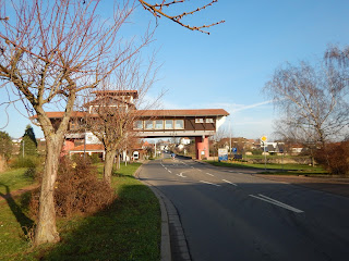
The name Weinsteig means Wine Route, with -steig indicating narrow, steep, climbing rather than wide or gentle. Today's route led us from well-kept, tiny Bockenheim through the surrounding vineyards up towards the crest of the Palatinate Hills. We passed a set of fine gates across the entrance to a vintners before reaching the Haus der Deutschen Weinstrasse, which makes a modern arch over the B 271 at the edge of the town.

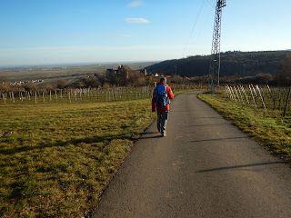
We followed red and white signs up into the vineyards, still naked and heavily pruned, gradually rising above the Rhine Plain. Gravel tracks, tarred roads, pausing to take in the landscape or watching the hawks wheel overhead. Small holes and runways suggested large populations of field hamsters or mice and despite the numerous lazily turning wind turbines, there seemed to be plenty of large birds of prey ready to eat them. We walked through open country, with copses of trees or bushes covering piles of limestone, along rows of vines and past occasional ancient signs of settlement. There was the blackened chunk of stone, perhaps the site of Celtic rituals, close by an early Christian chapel. For some time we met no one, then a family by a picnic table where we, too, stopped for a snack, and at the end of the day reckoned we had encountered nine people, including a woman on a horse.

We continued to climb and then descend into minor valleys, open fields much too green for January and then a steep descent into Mertesheim, once a centre of mining for ores. The road along the valley was the first we had seen or heard in the last couple of hours. From here onwards we were walking over sandstones, that produce infertile soils and are mostly left as woodland which covers nearly all the main uplands of the Palatinate Forest. Both of us were beginning to feel the effects of distance and height climbed, so we both needed cups of lemon and ginger tea and a power bar as we reached the top of the hill above Grünstadt. After walking through a small park we found ourselves leaving the woods again and realised that in the distance to the NE we could see the Donnersberg at 686m, the highest in the Pfalz. Onwards and around the next hilltop our view changed, back to vines, the horse and rider and below the line and drone of the A6 Autobahn. The road itself is well-known to us, one of our routes back to the UK, but it also meant that we were now very close to Neuleiningen. All day we had been buffeted by a chilly wind in our faces and now the low sun reminded us of the shortness of the daylight in January. We marched the next few kilometres, past farm and restaurant, to the road tunnel beneath the A6 and into Neuleiningen at a good pace.

We made it to the bus stop near the castle with about 10 minutes to spare, then into Grünstadt where the railway station still has the original Ludwig's Railway wrought iron stanchions holding up the wooden canopy. The Palatinate was ruled by Bavaria when the railway was built. A good day's walk in bright winter sunshine, where we had never been before.